Epistle from Cyprus XIV - 24th July 2007
Later today I will disappear over the internet event horizon when my telephone is disconnected and I was going to make this entry a final one with reflections over the year. I have decided to leave that until I have have had a little time to think about it a little and instead share one Cyprus' best kept secrets.
Several months back I was making one of my many sorties around the mountain villages. I had visited a large dam called Evretou and noticed tourists signs for something called the Skarfos Bridge. I decided to have a look and after a short drive and walk found a small arched stone bridge. The bridge no longer has water running under it because over hundreds of years the river has diverted and now runs by what would have been the northern approachway to the bridge.
 Skarfos Bridge
The location was so quiet I stayed around quite a while. The bridge is not near any of the more modern roadways and was part of an old trading network that ran to the heart of mountains in the centre of the island. The trade was in the copper ore that gives Cyprus its name. It was so peaceful I decided that when I got back home I would use the internet to look up any other mediaval bridges in Cyprus and then try and visit them. This proved a lot more difficult than I imagined.
Purely by coincidence in the following days I read an article in the local paper about some people who tried to visit some of these bridges that are located in the mountains and forests of central Cyprus and gave up without seeing any believing the bridges to be a myth.
I found a map with a series of three 'Venetian Bridges' marked on it and took the road to the nearest point a small town called Arminou. Now just because point A appears near point B on a map does not mean it is easy to get from A to B. The road became a loose dirt one which became a forest track which became a rutted nightmare.
If the hire car company ever find out I am sure I will be in big trouble. Eventually I was forced to turn back from finding one of the bridges and try in the opposite direction.
 The view from the mountain track approaching Kelefos
Here I had more success and was rewarded when I drove the car through a small ford and found the Kelefos Bridge (Tzelefos Bridge). This is a much larger bridge than Skarfos and has a small stream running under it. The water has been dammed to deepen it and wonder of wonders there are fish and small fresh water crabs. It is picnic area and on Sunday is popular with Cypriots which started me thinking how did they all get there. I found out when I continued on the road to the next bridge. The road was a good all weather surface which I should have used in the first place. The problem is you cannot see that on a tourist map where all the mountain roads appear as a yellow line of equal significance. Kelefos Bridge
The road lead to Elaia Bridge which is another impressive span over a riverbed that has been gouged out of solid rock over the millenia. Here the river was drying up in the intense summer heat. The last few pools of water were a veritable bouillabaisse filled with small fish struggling for oxygen. Seeing the mountain terrain over which traders with their caravans of camels would pass cannot fail to impress. Finding these places with a car and modern roads is difficult enough. Elaia Bridge
I had now almost completed my task of seeing the bridges but one remained ellusive and would have to wait to another day.
The final bridge is called Roudias and was by far the most difficult to locate. The fact that most of the internet references to Roudias referred to it because it is famous for its vultures and that I could not find a picture of it should have given me a clue. Having failed to find it from the most obvious direction on the map I tried the the opposite direction.
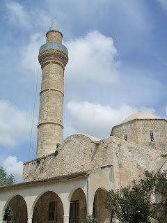
Once again the road ran out. I came to a deserted Turkish village which on the map is called Vretsia but is known to locals as Vrecha. You do start to worry a bit in these deserted villages when you can see that the minaret in the mosque has bullet holes in it. By a stroke of luck I ran into a forest ranger who told me that although I was only 2 kilometers from the bridge it was impossible to go directly there and I would have to double back on another route for about 5 kilometers. I will never know what the 2 kilometer road was like but the 5 kilometers seemed like 50. I had only 2 liters of water and apple and some dried apricots and was beginning to wonder how they would find my dental records out here in Cyprus.
Then I was there in the middle of it. I had found Cyprus's hidden heart. If Aphrodite lived and bathed anywhere in Cyprus it was here. Towering pine trees at the bottom of a mountain valley. The breeze is cool and the sound of cicadas fills the air. Butterflies are drinking by the river bank. As I walk down by the water's edge lizards dart back into the undergrowth and frogs leap into the safety of the water. Small fish hide in the depths as I approach and insects scoot across the surface.
And here too is the Roudias Bridge. Built against a natural rock outcrop it is the most beautiful and most impressive of them all. The river runs against the base of the rock and sweeps under the arch of the bridge. I was the only person there. I was the only person for miles. I had my own personal paradise. I basked in the dappled sunshine under the trees. I stripped and swam in the river and hoped that Aphrodite was not watching. Never did water and dried apricots taste so good. I found a coin on the riverbank and threw it back into the river for luck and for someone else to find. Roudias Bridge
Apologies for the poor quality of this picture which does not do it justice. I had dropped my digital camera and lost the memory card!
Eventually my time ran out. The real world was calling me back it's voice sifting through the forest. It was shouting. 'Money' it shouted. 'Work' it bellowed. 'Responsibility' it roared. I dried myself with my floppy hat and heeded the call.


